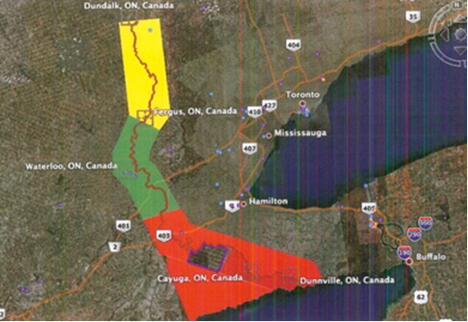
While the Haudenosaunee Confederacy Chiefs Council’s (HCCC) areas of jurisdiction over land are not limited by the drawing of lines on a map the HDI has attempted to provide an initial indication as to areas of Haudenosauee concern. In consultation with the people of the Six Nations of Grand River, the Tseh Niyoht Dwayadowhsra Ogwahweja (Haudenosaunee Green Plan) was created to set out areas of concern which are identified in progression of interest from:
- RED (areas requiring the highest level of review) to;
- YELLOW (areas requiring a high level of review); and,
- GREEN (areas requiring a significant level of review).
The Tseh Niyoht Dwayadowhsra Ogwahweja (Haudenosaunee Green Plan) was expressly undertaken so as not to create the impression that the Haudenosaunee areas of jurisdiction are limited to that area of land contemplated by the Haldimand Proclamation. It is important to recall that Haudenosaunee area’s of jurisdiction include those areas described in the Mitchell maps. Consistent with the importance of water to the Haudenosaunee people, the Tseh Niyoht Dwayadowhsra Ogwahweja (Haudenosaunee Green Plan) requires a 500-metre buffer zone to be established upon the banks of the Grand River.